 www.geodatenkatalog.de (S2L)
Contact for the resource
Alfred-Wegener-Institut (AWI)
4 record(s)
Provided by
Type of resources
Available actions
Topics
Keywords
Contact for the resource
Update frequencies
Service types
-
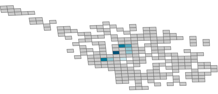
Description: Spatial distribution of selected demersal fish species in the German Bight. Data source: Data from environmental impact assessments (EIA) under the permit procedures of the Federal Maritime and Hydrographic Agency (BSH) in the North Sea EEZ and research data of the Alfred Wegener Institute (AWI), Helmholtz Centre for Polar and Marine Research; time period: 2000 to 2014, mainly spring and autumn data (EIA data), but also summer and winder data (AWI data) Sampling standards: Data of EIAs follow the standard investigation concept StUK 1-3 (BSH 2007), AWI data mainly collected in accordance with the ICES sampling standard (Rumohr 1999). Sampling gears: EIA-data with 7-8 m (partly 6 m) beam trawl (haul: 15 min), AWI-data with a 2-3 m beam trawl (haul: 5-15 min); trawling speed 3-4 kn, codend mesh size 10 mm Sampling: 1 haul per station and sampling date, data were recorded on board or subsamples were stored frozen for further analysis, analysis of abundance and biomass (kg wet weight) per species Data analysis: science information system of demersal fish data, examination of quality and plausibility, data harmonisation, product computation by AWI Product description: Grid: 10x10 km²; available selectable parameter: number of stations, minimum, maximum, mean, median and standard deviation of density (km-²) per species; classification method: natural jenks (Jenks Caspall algorithm); Note: The products contain a different classification of species density! Note: Please regard different value ranges! Note: Data refer exclusively to demersal fish species spectrum! Cited literature Rumohr, H. (1999). "Soft bottom macrofauna: Collection, treatment, and quality assurance of samples." ICES Techniques in Environmental Sciences, No. 27: 1-19. BSH (2007): Standard Investigation of the Impacts of Offshore Wind Turbines on the Marine Environment (StUK 3), Hamburg.
-

Description: Spatial distribution of selected macrozoobenthic species in the German Bight. Data source: Data from environmental impact assessments (EIA) under the permit procedures of the Federal Maritime and Hydrographic Agency (BSH) in the North Sea EEZ and research data of the Alfred Wegener Institute (AWI), Helmholtz Centre for Polar and Marine Research; time period: 1997 to 2011, mainly spring and autumn data (EIA data), but also summer and winter data (AWI data) Sampling standards: Data of EIAs follow the standard investigation concept StUK 1-3 (BSH 2007), AWI data collected in accordance with the ICES sampling standard (Rumohr 1999). Sampling gears: mainly van Veen grabs (0.1 square metre, 30-95 kg), few stations by box corer (0.1 square metre, 160 kg), Nephrops norvegicus and Goneplax rhomboides sampled by beam trawl and dredge (1-3 m width) Sampling: 1-3 replicates per station, fixation in 4 % buffered formalin seawater solution, dredge and beam-trawl data recorded on board or subsamples frozen stored, abundance and biomass (g wet weight) per species Data analysis: science information system of benthic invertebrate data, examination of quality and plausibility, data harmonisation, product computation by AWI Product description: Grid: 5x5 km² for grab data, 10x10 square kilometre for data on N. norvegicus and G. rhomboides from beam trawl and dredge hauls; available selectable parameter: number of stations, minimum, maximum, mean, median and standard deviation of density (m-2) per species; classification method: natural jenks (Jenks Caspall algorithm), Note: The products contain a different classification of species density! Note: Please regard different value ranges! Rumohr, H. (1999). "Soft bottom macrofauna: Collection, treatment, and quality assurance of samples." ICES Techniques in Environmental Sciences, No. 27: 1-19. BSH (2007): Standard "Investigation of the Impacts of Offshore Wind Turbines on the Marine Environment (StUK 3)", Hamburg. For more information, please visit: https://gdi.bsh.de/en/data/Benthos-Density_Information_Benthos_Dichte_DE.pdf
-
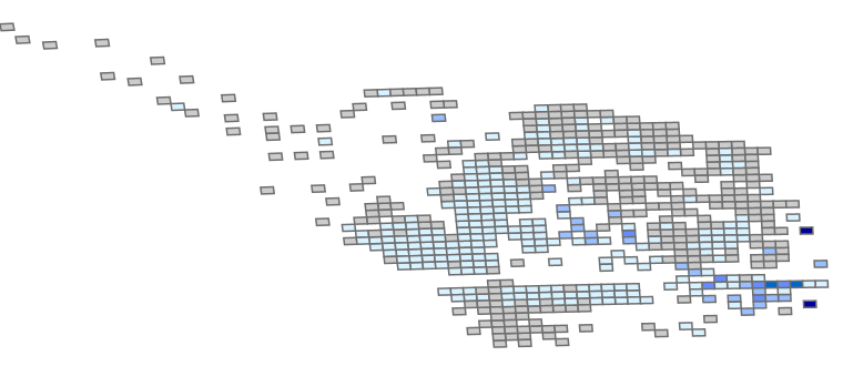
Description: Spatial distribution of selected macrozoobenthic species in the German Bight. Data source: Data from environmental impact assessments (EIA) under the permit procedures of the Federal Maritime and Hydrographic Agency (BSH) in the North Sea EEZ and research data of the Alfred Wegener Institute (AWI), Helmholtz Centre for Polar and Marine Research; time period: 1997 to 2011, mainly spring and autumn data (EIA data), but also summer and winter data (AWI data) Sampling standards: Data of EIAs follow the standard investigation concept StUK 1-3 (BSH 2007), AWI data collected in accordance with the ICES sampling standard (Rumohr 1999). Sampling gears: mainly van Veen grabs (0.1 square metre, 30-95 kg), few stations by box corer (0.1 square metre, 160 kg), Nephrops norvegicus and Goneplax rhomboides sampled by beam trawl and dredge (1-3 m width) Sampling: 1-3 replicates per station, fixation in 4 % buffered formalin seawater solution, dredge and beam-trawl data recorded on board or subsamples frozen stored, abundance and biomass (g wet weight) per species Data analysis: science information system of benthic invertebrate data, examination of quality and plausibility, data harmonisation, product computation by AWI Product description: Grid: 5x5 km² for grab data, 10x10 square kilometre for data on N. norvegicus and G. rhomboides from beam trawl and dredge hauls; available selectable parameter: number of stations, minimum, maximum, mean, median and standard deviation of density (m-2) per species; classification method: natural jenks (Jenks Caspall algorithm), Note: The products contain a different classification of species density! Note: Please regard different value ranges! Rumohr, H. (1999). "Soft bottom macrofauna: Collection, treatment, and quality assurance of samples." ICES Techniques in Environmental Sciences, No. 27: 1-19. BSH (2007): Standard "Investigation of the Impacts of Offshore Wind Turbines on the Marine Environment (StUK 3)", Hamburg. For more information, please visit: https://gdi.bsh.de/en/data/Benthos-Density_Information_Benthos_Dichte_DE.pdf
-
Description: Spatial distribution of selected demersal fish species in the German Bight. Data source: Data from environmental impact assessments (EIA) under the permit procedures of the Federal Maritime and Hydrographic Agency (BSH) in the North Sea EEZ and research data of the Alfred Wegener Institute (AWI), Helmholtz Centre for Polar and Marine Research; time period: 2000 to 2014, mainly spring and autumn data (EIA data), but also summer and winder data (AWI data) Sampling standards: Data of EIAs follow the standard investigation concept StUK 1-3 (BSH 2007), AWI data mainly collected in accordance with the ICES sampling standard (Rumohr 1999). Sampling gears: EIA-data with 7-8 m (partly 6 m) beam trawl (haul: 15 min), AWI-data with a 2-3 m beam trawl (haul: 5-15 min); trawling speed 3-4 kn, codend mesh size 10 mm Sampling: 1 haul per station and sampling date, data were recorded on board or subsamples were stored frozen for further analysis, analysis of abundance and biomass (kg wet weight) per species Data analysis: science information system of demersal fish data, examination of quality and plausibility, data harmonisation, product computation by AWI Product description: Grid: 10x10 km²; available selectable parameter: number of stations, minimum, maximum, mean, median and standard deviation of density (km-²) per species; classification method: natural jenks (Jenks Caspall algorithm); Note: The products contain a different classification of species density! Note: Please regard different value ranges! Note: Data refer exclusively to demersal fish species spectrum! Cited literature Rumohr, H. (1999). "Soft bottom macrofauna: Collection, treatment, and quality assurance of samples." ICES Techniques in Environmental Sciences, No. 27: 1-19. BSH (2007): Standard Investigation of the Impacts of Offshore Wind Turbines on the Marine Environment (StUK 3), Hamburg.